El Niño is strengthening. The West Coast is watching the ocean for clues
September 10, 2026 · By John Ian Lau
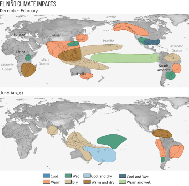
The Pacific has moved from forecast to watch. In its September 8 outlook, NOAA’s Climate Prediction Center said El Niño is present and strengthening, with a greater than 90% chance of a very strong event during the Northern Hemisphere fall and winter of 2026–27. The latest weekly sea-surface-temperature departures reached 1.8°C in Niño 3.4, 2.7°C in Niño 3 and 3.9°C in Niño 1+2, the agency reported.
That headline does not mean every coast changes at once. NOAA Fisheries’ West Coast briefing makes the distinction that matters for ports, fisheries and communities: El Niño is declared from tropical Pacific conditions, while its influence along North America arrives later. Eastern tropical Pacific temperatures have already risen more than 2°C above normal, but the West Coast typically waits a few months for the signal to travel north.
The first clue is not necessarily a dramatic wave. It is sea level. Westerly wind bursts can launch equatorial Kelvin waves that travel east and then turn north as coastal-trapped waves. Tide gauges and satellites can detect the resulting change in sea level—about 15 centimetres, or six inches, during a typical teleconnection. “Their impacts on the West Coast will likely be minor compared to this fall and winter,” said Nate Mantua, a research scientist at NOAA’s Southwest Fisheries Science Center, describing the Kelvin waves that reached California in May and June.
Water temperature provides a second signal. The waves deepen the thermocline, the underwater boundary where temperatures fall rapidly with depth. At the same time, atmospheric changes can weaken the winds that drive coastal upwelling, cutting off some of the cold, nutrient-rich water that normally reaches the surface. “The oceanic teleconnection is particularly impactful off Southern California, while the atmospheric teleconnection is more important off the Pacific Northwest,” said Michael Jacox, a NOAA research oceanographer. Together, the two pathways could produce unusually warm nearshore conditions from Baja California to Alaska.
Scripps Institution of Oceanography is framing the event as an observation challenge as much as a forecast. Shang-Ping Xie, a Scripps professor of climate science and physical oceanography, describes the coupled system this way: “Do we see the ocean side of El Niño or the atmospheric side first? But really it’s a chicken-egg coupled problem, because the atmosphere and the ocean are in contact and influence each other.” Scripps’ observing toolbox includes moored buoys, satellites and Argo floats, while its California Underwater Glider Network measures temperature, oxygen, salinity and currents down to about 500 metres.
Biology offers a more human-scale readout. NOAA Fisheries scientists are tracking warm-water visitors such as dorado, striped marlin and yellowfin tuna, but the agency cautions that marine heatwaves have already pushed some species north, making them less reliable as El Niño markers. Pelagic red crabs may wash ashore farther north when anomalous currents set in. Along Oregon, copepod diversity can reveal whether warmer subtropical source waters have replaced colder northern waters; that matters because the nutritional value of copepods helps determine how well young salmon grow.
For coastal decision-makers, the implication is practical. A forecast is not a single alarm bell but a chain of evidence: tropical heat, subsurface energy, sea-level changes, upwelling, species movement and seabird breeding success. NOAA’s Integrated Ecosystem Assessment and Scripps’ long-running observing programmes make that chain visible early enough to inform fisheries planning, beach management and public communication. Our mission is to illuminate the inner sparks of every life we touch through our efforts in ocean conservation and education. Together, we celebrate The Greatest Good